


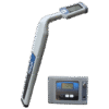
Stanlay Pathfinder PLDL Survey Grade RTK GNSS Mapping Pipe & Cable Route Tracer

Original price was: ₹230,000.00.₹220,000.00Current price is: ₹220,000.00.
The Pathfinder PLDL Survey Grade RTK GNSS Mapping Pipe & Cable Route Tracer is the most accurate combined cable pipe route locating & mapping equipment based on a single man operation.
The Pathfinder PLDL Cable Route tracer is equipped with 36 frequency options of low frequency of 200Hz to 1kHz and with further options of 8kHz up to 476.2Khz. Navigational aids include Left – Right Arrow, Compass for orientation, 8 operating modes including Pin-Point peak to allow route tracing of specific cables in congested buried utility network with a powerful 12-watt transmitter. It also offers USB 5V power output to the Trimble DA2 GNSS receiver which is mounted directly on Pathfinder PLDL survey grade utility locator.
- Route tracing of Medium to Long Distance Cable or Pipe Routes, with High Accuracy
- GNSS Receiver directly mounted & powered by Locating receiver, to allow single person usage
- GNSS receiver is RTK/RTX Capable providing accuracy up to 5cms accuracy with correction hub service
- Measure depth of cables or pipes at high depth, typical of HDD installations
- Detect buried energised power cables & un-energised cables or pipes
- Navigational Aids include Compass, Left – Right Arrow to guide operator
The DA2 is the Next generation Trimble Catalyst (L1/L2/L5) GNSS RTK receiver which delivers survey-quality GNSS positioning to location-enabled Android phone. Cable Route tracing of Medium to Long Distance Cable routes with simultaneous acquisition of GNSS coordinates with High Accuracy of up to 5cms (Or 60 cms based on RTX correction service selected), Cable Depth Data & Asset Images.
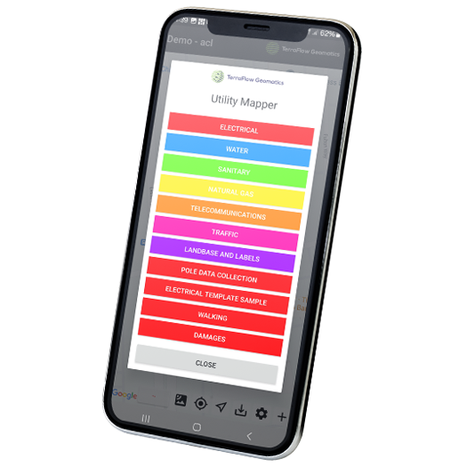
The Terra Flow Utility Mapper Mobile App can be installed on any dual Bluetooth android mobile phone & connects to both the Pathfinder PLDL Cable Route tracer & the DA2 GNSS Receiver. Mobile App fetches data acquired includes Route traced, GNSS coordinates of route, Depth data, GNSS error, Date/time of trace acquired and synchronized through cloud with Map data generated automatically for viewing or downloading in office. Data collected in field is Automatically updated to server & Maps can be downloaded in office in real time without further need for emails, file sharing etc.
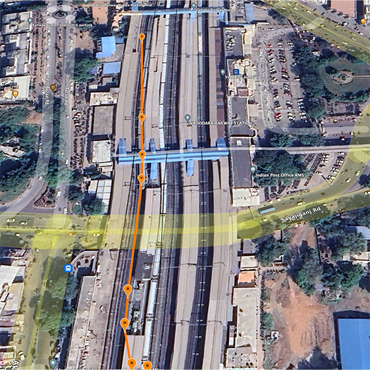
Digital Maps created Automatically with no further human intervention required. Access GNSS coordinates of cable route with depth & images. Data can be downloaded in. kml (Pictorial map in google earth), AutoCAD, .shp (Shape files) or download data logs in .csv (including Date/time of route trace). It is also possible to add sketches to existing maps for project planning.
The Pathfinder PLDL is the ideal solution for creating Digitized maps of existing cables & pipe routes with pictorial view maps & images.
Pathfinder PLDL Technical Specifications:
| Parameters | Pathfinder PLDL |
| Active Mode Transmitter Mode Available Operating Frequencies | >36 User configurable frequencies: 200Hz, 256Hz, 273Hz, 340Hz, 400Hz, 460Hz, 512Hz, 560Hz, 570Hz, 577Hz, 640Hz, 760Hz, 797Hz, 815Hz, 870Hz,920Hz, 940Hz, 1.01kHz, 1.02kHz, 1.10kHz, 1.45kHz, 4kHz, 8.192kHz, 8.4kHz, 8.9kHz, 9.8kHz, 29kHz, 33kHz,51kHz, 65kHz, 82kHz, 83kHz, 93kHz, 116kHz, 118kHz, 131kHz, 145kHz, 200kHz, 262kHz, 478kHz |
| Passive Modes | Power Mode : 50Hz & 60Hz Live Sound , Radio Mode (RF) , Rectified CP |
| Power Filters | Built in |
| Power Harmonics | 50Hz, 60Hz, 150Hz,180Hz, 250Hz, 300Hz, 350Hz, 420Hz, 450Hz, 540Hz |
| Antenna Mode | Simultaneous peak/null (dual horizontal antennas & vertical antenna), pin-point peak (dual horizontal antennas), directional guidance, peak (single horizontal antenna) & null (single vertical antenna) |
| Display Indicators | Backlit segmented LCD bar graph, battery condition, continuous mode signal strength, depth measurement, line orientation, left /right line guidance, operating mode, volume level & function indicators |
| Navigation features | Left Right Arrow, Compass Mode for Orientation, for Cable Route & Identification |
| Current Direction | Up/ Down Current Direction with built in CD frequency |
| Push Button Selection | 6 Buttons for Power, Frequency, Mode selection, Shift/Log/Depth/P-Link, Gain or Up & Down. |
| Audio Indication | Variable pitch & Tone change (solid / pulsed) on either side of target utility, 4 volume selections including mute |
| Vibration | Vibrating handle |
| Current Measurement | Display indicates relative current |
| Display | Large LCD Display, Backlit, (4” Diagonal, 2.5” x 3.1”) |
| Power Source | Lithium-Ion Rechargeable battery |
| Battery Life | Continuous: 30 hours Intermittent: 82 hours |
| Signal Strength | LCD bar graph, absolute signal strength 0-999 |
| Gain Control | Manual gain adjustment & automatic centering |
| Dynamic Range | 126 dB |
| Interference protection from high tension lines | Automatic Overload Protection |
| Depth Measurement | DIGITAL: 3-digit LCD readout .02m-10.6m | Accuracy: ± 3% Depending on Frequency & Depth I Optional : Upto 20m |
| Units | Metric / Imperial, based on user selection |
| Live Measurement | Depth & Current, simultaneous at user option |
| Operating Temperature | -20º C to +55º C |
| Dimensions | Weight | 77cm x 24cm | 1.9kg ± 0.1kg |
| Environmental | IP65 water & dust proof |
| Connectivity* | |
| Wireless Communication | Bluetooth |
| USB | 5V Output for powering DA2 GNSS Receiver |
Transmitter Technical Specifications:
| Model Options | Pathfinder PLDL |
| Max Output power | 12W |
| Active line frequencies | Upto 36 user configurable frequencies: 200 Hz, 256 Hz, 273 Hz,400 Hz, 512 Hz, 560 Hz, 570 Hz, 577 Hz, 640 Hz, 760 Hz, 797 Hz,815 Hz, 870 Hz, 920 Hz, 940 Hz, 1.01 kHz, 1.02 kHz, 1.1 kHz,1.45 kHz, 4 kHz, 8.192 kHz, 8.4 kHz, 8.9 kHz, 9.2 kHz, 32.768 kHz,65.53 kHz, 82.70 kHz, 83.00 kHz, 93 kHz, 116 kHz, 117.850 kHz,1131 kHz, 145 kHz, 200 kHz, 262 kHz, 476.2 kHz + 3 Dual frequencies: 815Hz /82kHz, 82kHz/33kHz, 8Hz/82kHz |
| Load matching | Automatic 5 to 25000 ohms |
| Display | LCD |
| Indicators | AC load assistance measurement, relative ohms, voltage, live voltage output, current output, frequency, mode, battery indication alert, low battery indicator audio/visual with modulated low battery warning transmitted to the receiver |
| Output power setting | 10 power settings Low & Medium Frequency Range: 0.2 to 12 Watt (<8kHz); 10 Watt (8 to 44kHz) |
| High Power Output Mode | Yes, Voltage Boost upto 130 Volts |
| DFF mode | Yes, DFF Mode can be used for sheath fault locating (Earth return probe / A frame is purchased separately) |
| Power source | Lithium-Ion Rechargeable battery , Li-ion battery charger included |
| Operating time | Continuous: 8 ~20 hours depending on load, frequency, power setting. Intermittent: 40 ~60 hours |
| Weight | 2.7kG |
| Size | 41 cm x 16 cm x 15 cm |
| Operating Temperature | -20°C to 55°C |
| Environmental rating | IP65 |
DA2 GNSS Technical Specifications:
| GNSS PERFORMANCE | |
| Code Differential (DGPS) | |
| Horizontal accuracy | 0.3 m + 1 ppm RMS |
| Vertical accuracy | 0.6 m + 1 ppm RMS |
| Single baseline (<30 km) RTK | |
| Horizontal accuracy | 10 mm + 1 ppm RMS |
| Vertical accuracy | 20 mm + 1 ppm RMS |
| Network RTK | |
| Horizontal accuracy | 10 mm + 0.5 ppm RMS |
| Vertical accuracy | 20 mm + 0.5 ppm RMS |
| Trimble RTX™ (using Trimble Corrections Hub) | |
| Horizontal accuracy | 2 cm RMS |
| Vertical accuracy | 5 cm RMS |
| Positioning rate | 1 Hz, 5 Hz, 10 Hz |
| SIGNAL TRACKING | · Trimble ProPoint GNSS positioning technology for improved accuracy and productivity in challenging GNSS conditions1 · GPS: L1C/A, L2C, L5 · GLONASS: L1C/A, L2C/A · SBAS: L1C/A, L2C, L5 · Galileo: E1, E5A · BeiDou: B1, B2A · QZSS: L1C/A, L2C, L5 · NavIC (IRNSS): L5 · Digital channels: Software controlled by Catalyst dynamic signal tracking using mathematical channels |
| Communications/Connectivity | |
| Bluetooth | 4.2 |
| Apple | Made for iOS certified |
| Ports | USB-A (Power only) |
| Data protocols | NTRIP, VRS, RTCM 3.x, CMRx , DCOL |
| Position output | NMEA (LLH), DCOL |
| Supported Platforms | |
| Android | Android 5.0 (Pie) and higher |
| iOS | iOS 13.0 and higher |
| Battery & Power | |
| External power input | USB-A (5 Vdc 1 A) |
| Power consumption | 0.5–2.5 W |
| Environmental | |
| Operating ambient temperature | −20 °C to 60 °C |
| Operating humidity | 95% RH, non-condensing |
| Operating altitude | Tested to 9,000 m (29,500 ft) |
Only logged in customers who have purchased this product may leave a review.
Related products


FIBER MODEM & ROUTER XPON ONT / ONU


FIBER ACCESSORIES
Syrotech Single Mode SINGLE Fiber Pacth Cord SC/UPC to SC/UPC -CONECTOR 5 MTR (PACK OF 10PCE)


FIBER MODEM & ROUTER XPON ONT / ONU


FIBER ACCESSORIES
SYROTECH PLC SPLITTER WITH CONNECTOR SY-PLC-ST-1X2-SCP-1A PLC SPLITTER (PACK OF 2PCE)


FIBER MODEM & ROUTER XPON ONT / ONU


FIBER MODEM & ROUTER XPON ONT / ONU


Reviews
There are no reviews yet.